I've driven past the turnoff to Blue Waterholes more times than I can count. This trip I finally stopped.
This is Part 2 of the NSW High Country series — Part 1 covers the drive in from the Brindabella Ranges, the camp at the river ground near Coolamine Homestead, and the first look at the cheese hut. This one is about what we found when we actually explored it properly: the homestead's history, the Clark Gorge Walk, and a candid take on whether Blue Waterholes deserves its reputation.
Coolamine Homestead — A Proper History
The first structure on this site went up in 1839 — a slab and bark hut built for Stuart Mhler (phonetically; likely Stewart Mowle), an overseer for Terrence Murray. The same Murray family, incidentally, that owned the land where Government House in Canberra now stands.
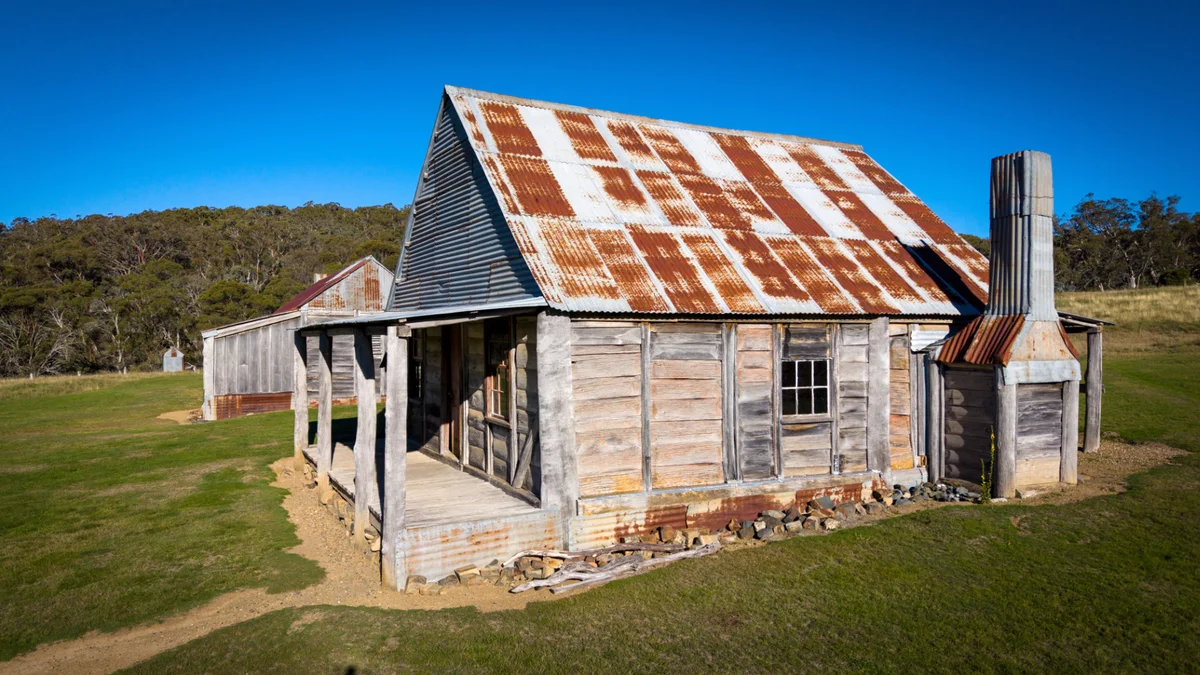
The main building you see today — Campbell's House — was built in 1883 by the Southwell family as a base for their grazing operations on the Cooleman Run. Classic high country slab construction: hand-hewn timber, small windows. The interior walls are lined with old newspaper from the early to mid-1900s. You can still read the headlines and the advertisements. That's not a tourist feature — it's just what was there and it survived.
Over the years, more slab buildings, sheds, and yards were added. Stockmen and their families lived here through the summer months. By the late 1960s and into the 1970s, the whole complex was falling apart.
When the area became part of Kosciuszko National Park in 1977, things changed. In the 1980s, volunteers from the Kosciuszko Huts Association stepped in using a government heritage grant. They rebuilt using local timbers, traditional hand tools, and period methods — salvaging as much original material as possible. A 2007 conservation management plan describes Coolamine as having "an unparalleled range of vernacular bush building techniques for New South Wales."
And yes — there's a two-seater dunny. Side by side. I've seen a lot of outback dunnies. That was a first.
If you want to see how the restoration was actually done — a bushman felling trees with axes and crosscut saws, splitting slabs by hand — this video covers it. Proper old school bush carpentry.
The Clark Gorge Walk — What to Expect
The walk starts at Blue Waterholes and follows Caves Creek through a narrow limestone gorge to Coolamine Falls. The stats from this trip:
| Distance | 6.7 km return |
| Elevation | ~153 m |
| Moving time | 2 hrs 24 min |
| Total time | ~3.5 hrs (including caves and cold dip) |
| Creek crossings | 9 — each ~20–25 m wide |
Rated medium to hard. It earns that.
Coming back along the track we passed a walker who made it very clear: you will get wet feet. Went back to the car, swapped into an older pair of trail shoes, and accepted the inevitable. Don't try to keep your feet dry by jumping between rocks. The rocks are slippery, the crossings are wide, and the effort isn't worth the risk. Just walk through.
The gorge walls are limestone — some of them over 400 million years old. It's genuinely impressive in a way that photographs don't fully capture. Cold, clear water running between cliffs that high. Between crossings, some pools reach waist depth and are cold enough to get your attention even on a warm day.
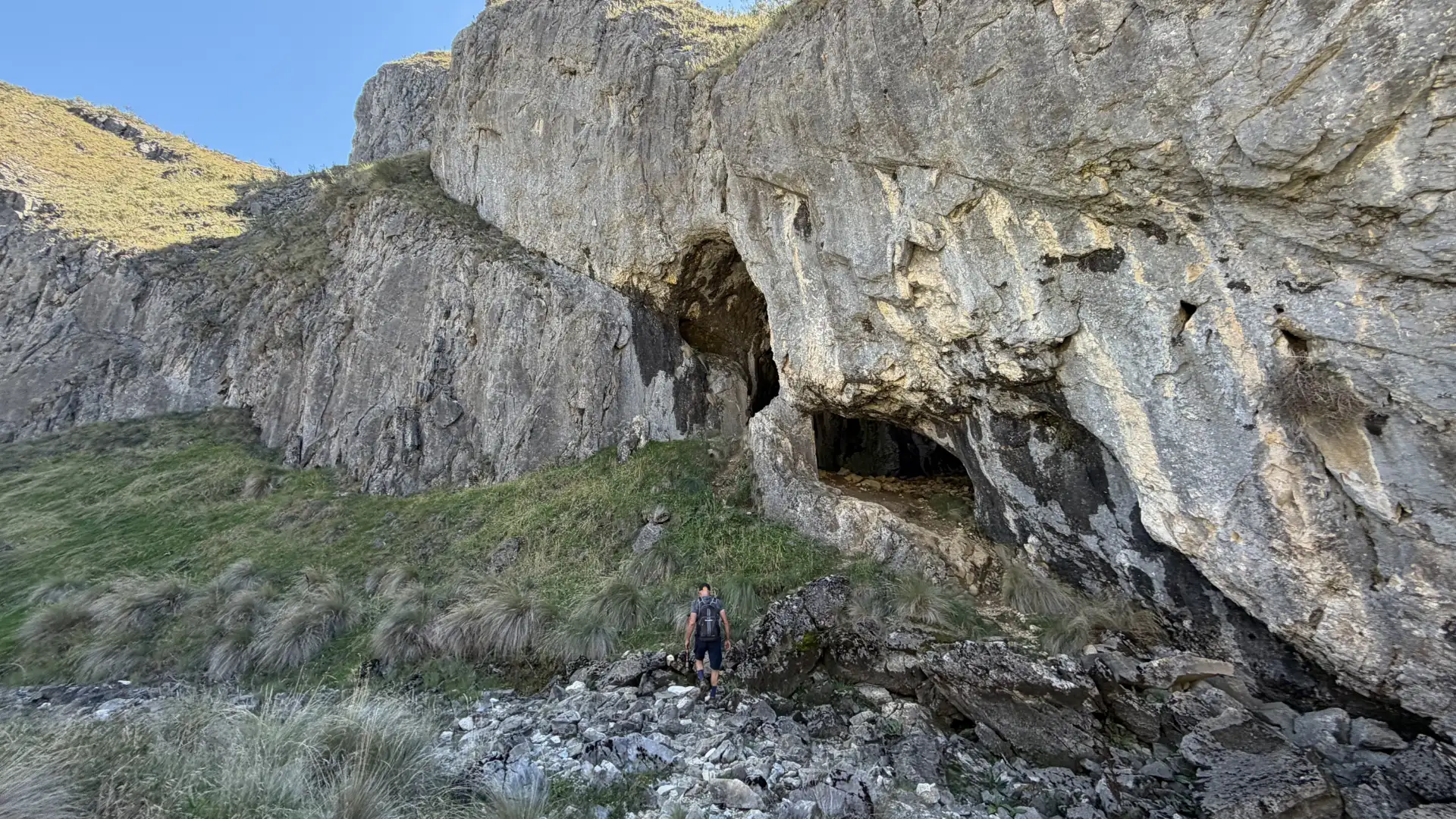
There are several small caves tucked into the gorge walls along the route. We explored a few. On the plains above, one cave slot had cold air coming out of it — the deepest thing we found cave-wise on the day.
Coolamine Falls and the New Steps
The Wild Walks team had just finished building new access steps from the top of Coolamine Falls down to the base. We were among the first people to use them.
The falls are 15 metres. Before the new track, getting to the base was a proper rock scramble. The new steps are a welcome improvement — there are still some narrow sections along a reasonable drop, but it's manageable. Not for people afraid of heights, but nothing extreme.
Below the main falls there are a few smaller drops, but getting to those involves scrambling over very slippery rock.
After the falls, we found round rock pools at the top — submersed briefly to rinse off three and a half hours of gorge sweat. The water was cold enough that "quick submersion" is the accurate description.
One of the best day walks I've done in Kosciuszko. It earns the difficulty rating through terrain, not distance. I cannot believe I hadn't done it before.
I had my Leki poles the whole way — Dan had one, I had two, and they were genuinely useful on the slippery sections. For this walk specifically, bring them if you have them.
Blue Waterholes — The Honest Verdict
The blue-green colour comes from calcium carbonate dissolving out of the surrounding limestone — spring-fed water filtering through karst country. The colour is real and unusual.
But overrated? Yes.
The main pool has a fair amount of algae. The "Blue" Waterholes are more of a "Green" Waterholes these days. My travel companion confirmed this had been the situation on his previous visit too. For swimming, the pools in the Clark Gorge are a better option by a significant margin. Blue Waterholes is worth a look on arrival, but by the end of the day it's not the highlight of the visit. The gorge already took that title.
GME PLB MT620GR — Return Link Service Explained
I've been using GME PLBs for over a decade. I have the 610 version in each of my vehicles. The MT620GR — which GME supplied to me a few months before this trip — lives in the hiking bag specifically.
The key difference is Return Link Service (RLS).
With a traditional PLB, you trigger it and wait. You have no idea whether the signal was received by emergency services. With RLS: when emergency centres receive your signal, blue lights on the unit start blinking. That confirmation tells you help is on the way.
The practical consequence goes further than you'd think. Studies show that if you know help is coming, you survive longer when critically injured — you hold out. RLS provides that psychological certainty. If the blue lights don't blink, you know the signal wasn't received, and you can try to move to a better position before re-triggering.
The MT620GR also uses more satellite constellations than previous GME models.
If you go bush in any capacity — 4WDing, bushwalking, hunting — have a PLB with you. The full review is here.
Navigation — Memory Map
Navigation for both days was done with Memory Map For All loaded with the HEMA 4WD maps. In Kosciuszko, where high-country trails aren't reliably on general-purpose apps, having proper offline topo detail made route-finding straightforward — and it won hands-down over every other app I've tested. More in the full review.
Gear Notes
The Katadyn BeeFree filter came with me in the hiking bag and got used filtering spring water at Blue Waterholes. Compact, light, and it's been reliable across multiple trips now. Stays in the bag.
After the walk, we had Campers' Pantry Thai Green Curry for lunch. Good flavour, genuinely Thai, could handle more chilli. Solid meal after a 3.5-hour gorge walk.
Next episode: Nichols Gorge Walk, Murray Cave and Coolamine Cave. The Cooleman Plains have more to give. See you along the tracks.